New map unlocks deep digital data of Antarctica’s history
By GNS Science
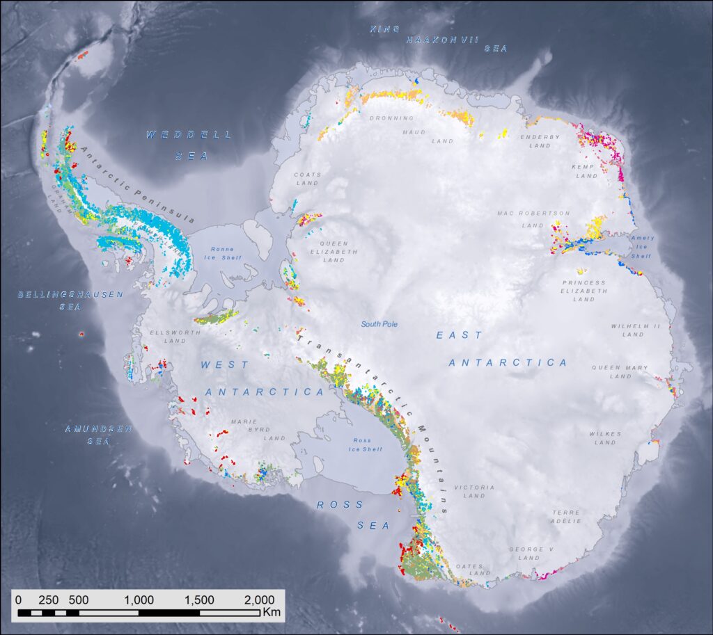
It’s not just ice out there. 0.5% of the surface of Antarctica is exposed geology which can tell us a lot about the history – and the future – of the continent. GeoMAP Antarctica is the first detailed digital database that collates all the historical and existing geological data of Antarctica. The data can be downloaded for free and visualised in 3D.
GeoMAP Antarctica is a ground-breaking transformation in Antarctic research, and a new way to understand the frozen continent.
The project is a documentation of the first open-access and comprehensive geological mapping database of Antarctica, and was released in Nature Scientific Data. ACEAS Chief Investigator Dr Jacqueline Halpin was part of the project.
Understanding Antarctica’s geosphere is, and has been, critical for understanding the continent’s major role in global climate—and thus, our future.
Despite Antarctica’s reputation as an icy expanse, more than 52,000 km2 of exposed rock and sediment make up the mountains and surfaces of the continent. Each of these areas contain important information on the continent’s geological, geomorphological, and glaciological history.
Simply, rocks play an important role in—and tell us a lot about—the complex interaction of land, atmosphere and climate. Geological knowledge of the continent’s mountains, sediments and soils helps pinpoint the location, history and movement of glaciers, and even meltwater production. These insights provide foundational knowledge for researchers, from climate scientists, to biologists, to ecologists and volcanologists.
Therefore, having an accurate digital record of the continent’s known surface geology is invaluable to researchers in the coming years.
Seeking to build this record, an international team created GeoMAP to be the first detailed digital database that collates all the historical and existing geological data of Antarctica.
Now published, GeoMAP is the world’s first, and only, open-access resource that provides this detailed geological account of what we know about the frozen continent, all in one place.
Constructing GeoMAP was a large, and long-term, international effort led out of the Scientific Committee on Antarctic Research (SCAR) by GNS Science in New Zealand. The project involved principal collaborators from Australia, USA, Norway, Italy, UK, Russia and New Zealand, with further contributions from at least 14 nations.
Geological study has taken place in Antarctica for over a century, so constructing GeoMAP to compile the existing geological knowledge into one place, took several years. The research effort included interpreting information from beautiful 20th Century hand-drawn maps, digitising hard-copy regional maps, and then integrating them with modern high-resolution datasets.
Project leader, Simon Cox from GNS Science in New Zealand says, “In many ways GeoMAP is like a Wikipedia of Antarctic geology. We purposefully created GeoMAP to be a fundamental, continent-wide, and open-access collection of datasets of geological information, compiled into a modern mapping framework. We believe GeoMAP will be used in, and evolve with, a wide breadth of future research across the world.”
“The map is amazing and a huge contribution to the scientific community. This is, I think, a significant legacy for the GeoMAP team that will be a useful tool for any researcher wishing to tie the abundance and distribution of biology to the local geology,” says Professor Craig Cary, Microbial Biologist, University of Waikato, New Zealand.
Lead data architect, Belinda Smith Lyttle from GNS Science says, “There are still many areas in Antarctica yet to be visited by any geologist, and other areas where very detailed mapping has yet to be captured—and there is always new research taking place—so the GeoMAP database has been designed to be editable and improved over time.”
To construct GeoMAP Antarctica, the team adapted the methodology developed by GNS Science to build the geological map on New Zealand. This effort was made possible by the co-funding from GNS Science’s Nationally Significant Databases and Collections Programme (NSDC), which is supported by the New Zealand Government’s Strategic Science Investment Fund. This New Zealand led effort was also enabled by a core-team of passionate collaborators across the globe.
GeoMAP also supported a global team of dedicated student volunteers who visited New Zealand from Italy, Norway, Australia, United Kingdom and the United States. They contributed to this world-first project in return for some on-job training and a chance to examine the icy continent carefully.
For geological knowledge, GeoMAP compliments Antarctica’s reputation as the “continent of science and collaboration”.
Nations contributed maps from their previous geological surveys to be summarised into GeoMAP. The project team ensured that all original work can be found and referenced easily within the GeoMAP database. Local experts across the globe then rigorously checked and reviewed data. The philosophy ‘the whole is greater than the sum of its parts’ therefore now rings true for geological knowledge of Antarctica through GeoMAP.
The work of GeoMAP will facilitate the ongoing mission of the Scientific Committee on Antarctic Research (SCAR) to coordinate international understanding of Antarctica through a common platform.
Simon Cox says, “Our whole GeoMAP international team is now proud to say, the entire dataset can be accessed online, downloaded for free by anyone who wants to know more about Antarctica. This publication in Nature Scientific Data provides a handbook for its use and highlights the global importance of the data.”